
Yame city, Fukuoka is a consistent origin site of Japan’s best gyokuro teas.
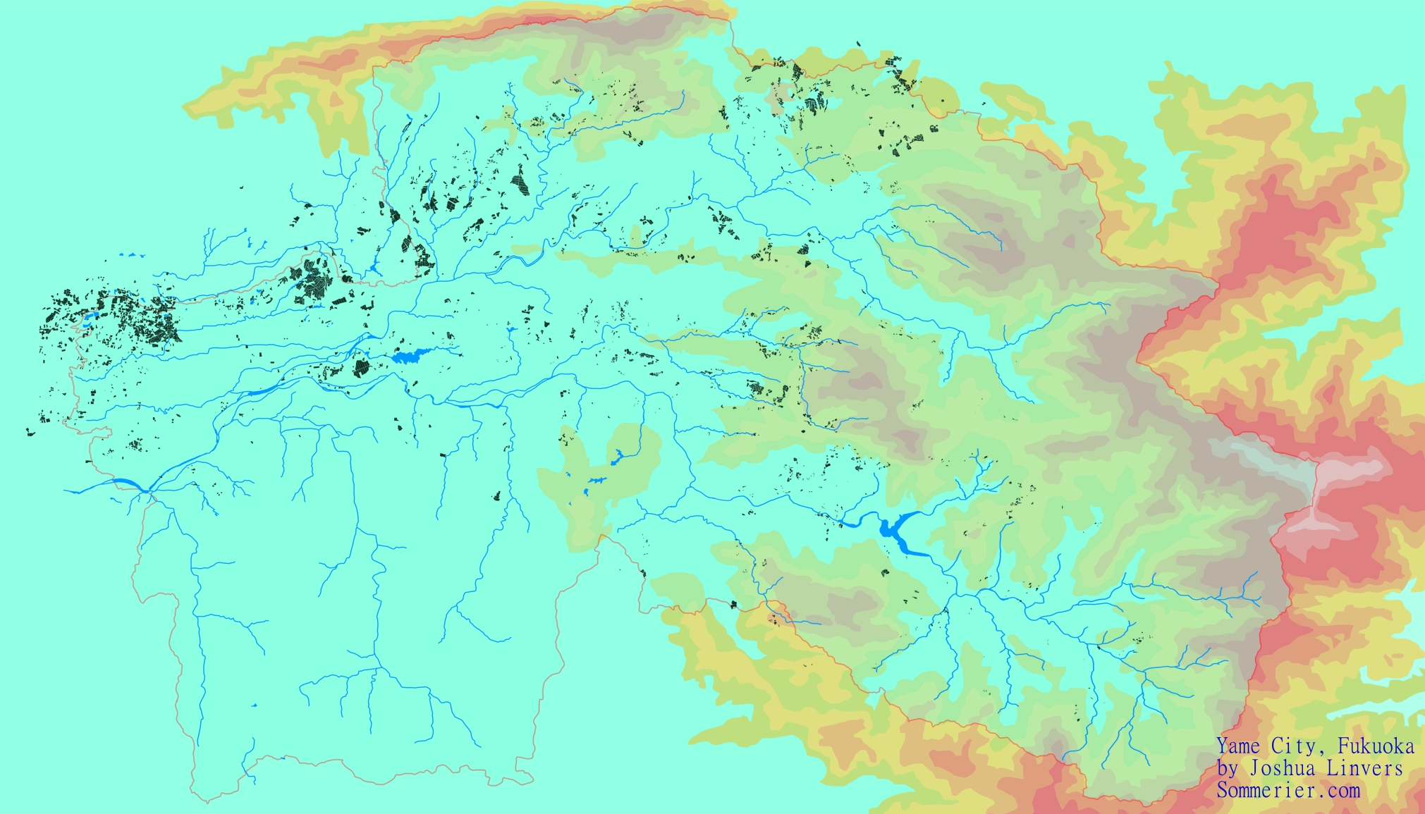
In the very dark green (looks black) is an outline of every tea farm in Yame. If I missed any, my bad, this is ≥ 90%, probably 95%.
You can see the tea fields locations relative to each other. The urban area where most people live is on the Western border in and between the biggest clusters of tea farms, and stretching down to the rivers in the central west.
The map was pieced together from over 70 satellite images stitched together, topographical maps, political maps, etc. The nature of using satellite images and doing it this way means that if the sizing is not perfect, it will create a cascading error. I manually corrected these errors the best I could.
This is not perfect, but I don’t think I can do better, and compared to any other tea map of Yame I’ve ever seen; this is vastly superior and should give anyone interested a very good sense of the tea industry here. This map took me over 80 hours to complete, this image is just 8.5% size of the original. The full size is 8GB and is something like 12′ x 21′ in reality. Feel free to use it, but if you do, please leave my watermark on. This was an extremely tedious job to do.
—-
What I hope this map answers: 1) What is the value of land, or “terroir” in gyokuro? sencha? etc. Even without tasting teas, we can approximate this answer statistically from data of the national tea competition. I believe we can find this out by finding the location of each winning farm, putting a pin in them, and looking for correlations. If it happens that winners consistently come from a specific area, then perhaps the neighbouring farms may produce great products too that are flying under the radar. Pretext to that above question is: What is the value of land vs the value of the tea maker. If it turns out that all of the winners come from Yame’s central tea plantation (the 2nd biggest cluster of farms from the left of the image) — why bother with the concept of terroir at all? The highest ranking gyokuros are born in Yame, Kyotanabe, and Asahina/Fujieda. If terroir wasn’t responsible for at least a major part of this, we should see more diversity in origin, I guess. —- The next step is to input information about the farms, which are private, which are cooperatives, which produce gyokuro, tencha, sencha, etc. If anyone is interested in helping with this, I’d be glad to have a partner. —-
福岡県八女市
地図上の非常に濃い緑色(ほとんど黒に見える部分)は、八女市内の茶畑の全域を示しています。もし見落としがあったらすみませんが、ここに反映されているのは少なくとも90%(おそらく95%)ほどです。 この地図では、茶畑同士の位置関係をご覧いただけます。住民が最も多い市街地は、西側の境界沿いや大きな茶畑のクラスターの間に位置しており、西部中央の川沿いにまで広がっています。
この地図は、70枚以上の衛星画像や地形図、行政区画図などをつなぎ合わせて作成しました。衛星画像を使ってこのように作り上げるため、サイズが完全に合わない場合に連鎖的なズレが生じますが、それを可能な限り手作業で修正しました。 完璧とは言えませんが、これ以上の精度は難しいと思います。それでも、私がこれまでに見た八女の茶地図の中では圧倒的に優れており、興味のある方には八女の茶産業の全体像を把握するのに大いに役立つはずです。
この地図の完成には80時間以上かかりました。この画像はオリジナルのわずか8.5%のサイズで、フルサイズは8GBほどあり、実寸では約12フィート×21フィート(約3.7m×6.4m)になります。 自由にお使いいただいて構いませんが、その際は私のウォーターマークを残していただけると助かります。非常に手間のかかる作業でしたので……。
この地図によって明らかにしたいこと:
1)玉露や煎茶などにおける土地(テロワール)の価値はどのように評価できるのか。 実際に茶を飲み比べなくても、全国茶品評会などのデータを使えば統計的にある程度推測が可能かもしれません。受賞農園の所在地を地図にピン留めし、相関を探るという手法です。もし特定のエリアから継続的に受賞者が出ているなら、その近隣の農園にもまだ世に知られていない優れたお茶を作る潜在力があるかもしれません。
この問いの背景としては、「土地そのものの価値」と「茶生産者(茶師)の技術の価値」をどう評価するか、という点があります。もしすべての受賞者が、地図で左側から2番目の大きなクラスターに当たる八女中央部の茶園だけから生まれているのであれば、そもそもテロワールという概念が必要なのか、という疑問もわいてきます。
最高級の玉露は八女、京田辺、そして朝比奈/藤枝で生まれています。もしテロワールが大きな要因ではないのなら、産地のバリエーションはもっと広がっているはずだと思うのですが……。
次のステップ 今後は、各農園が個人経営なのか共同組合なのか、玉露・碾茶(てんちゃ)・煎茶などどの種類を生産しているのか、といった情報を地図上に落とし込んでいきたいと考えています。もしご興味をお持ちの方がいらっしゃれば、ぜひ一緒に取り組んでいただきたいです。
Leave a Reply
I would love to hear from you